Descobrir Batalha

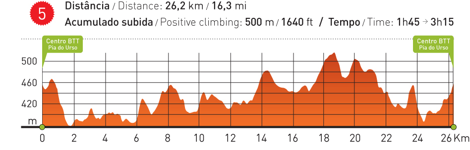
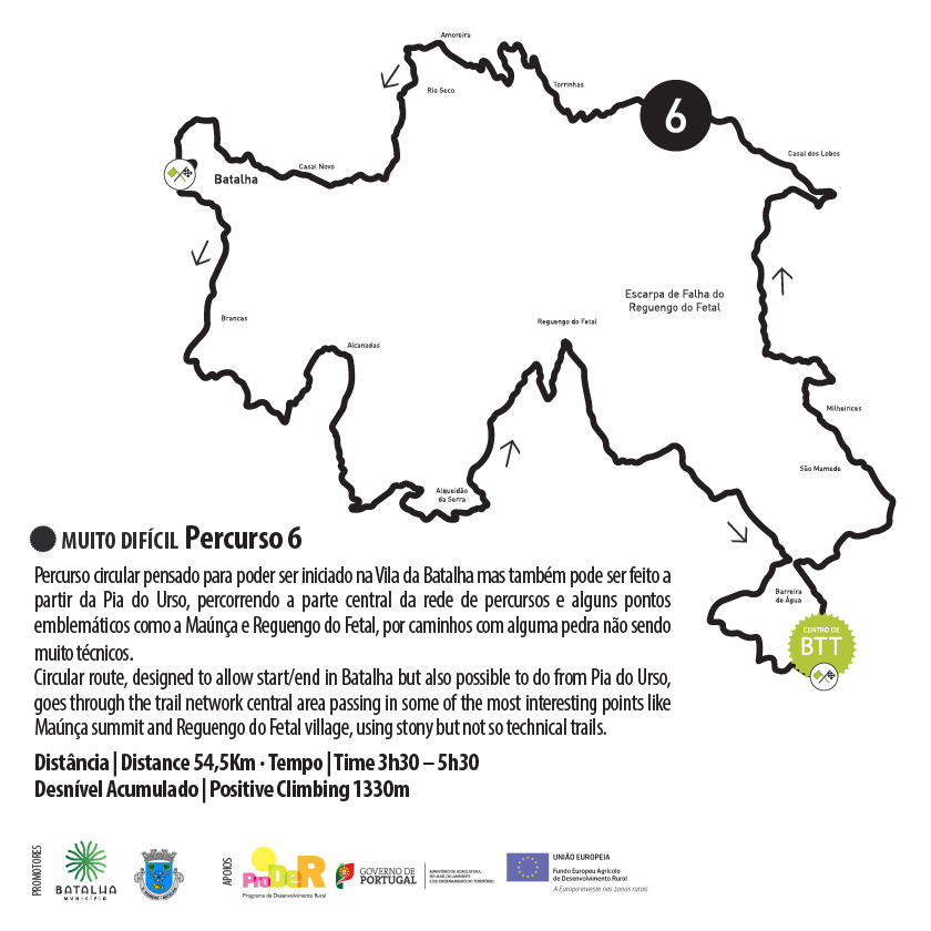
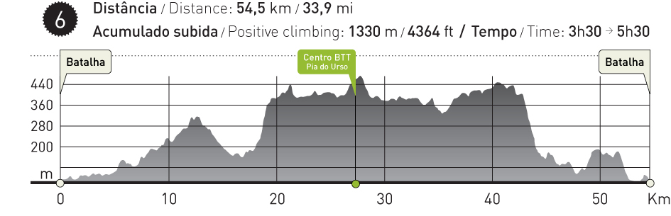
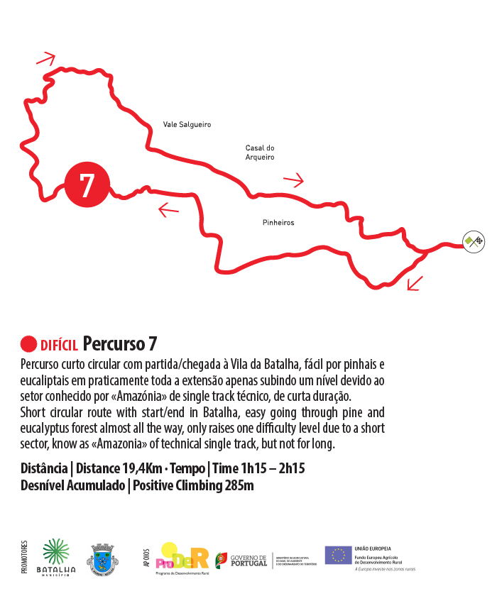
Batalha Mountain Biking Centre

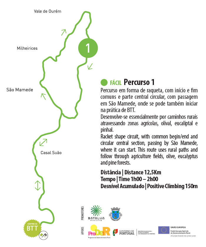
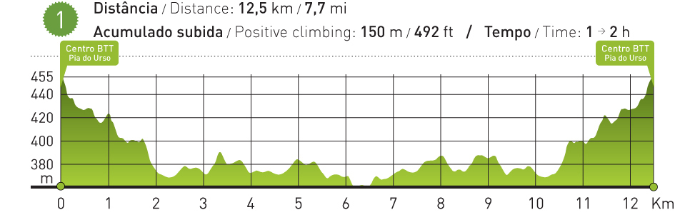
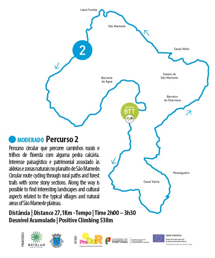
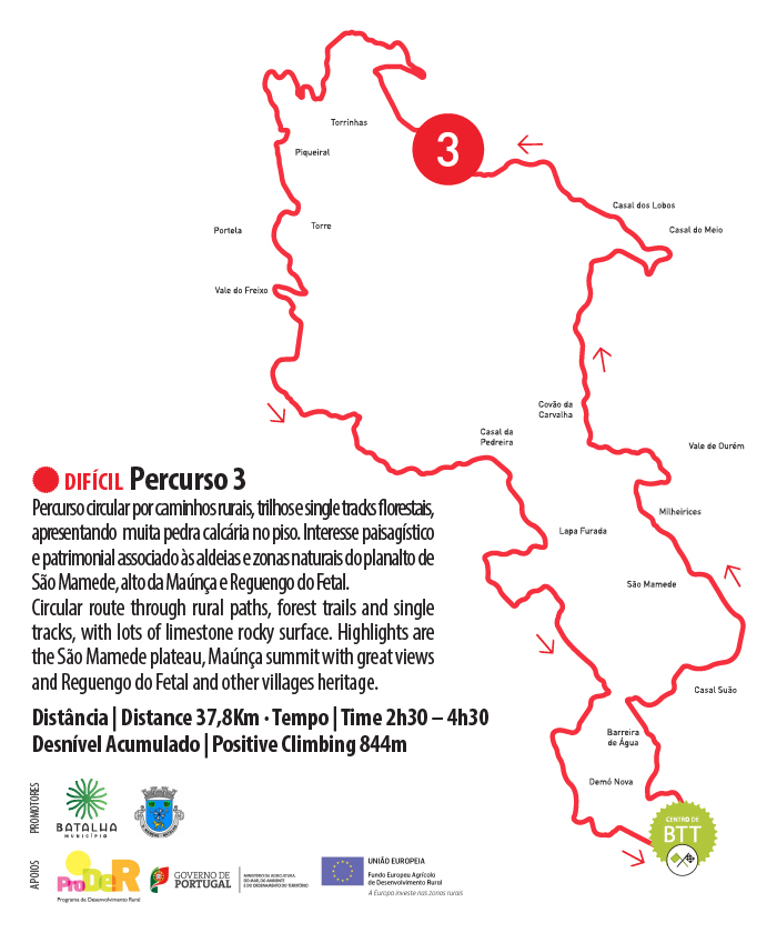
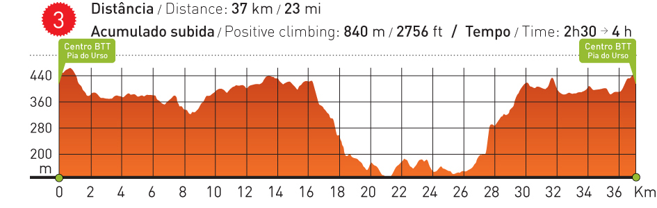
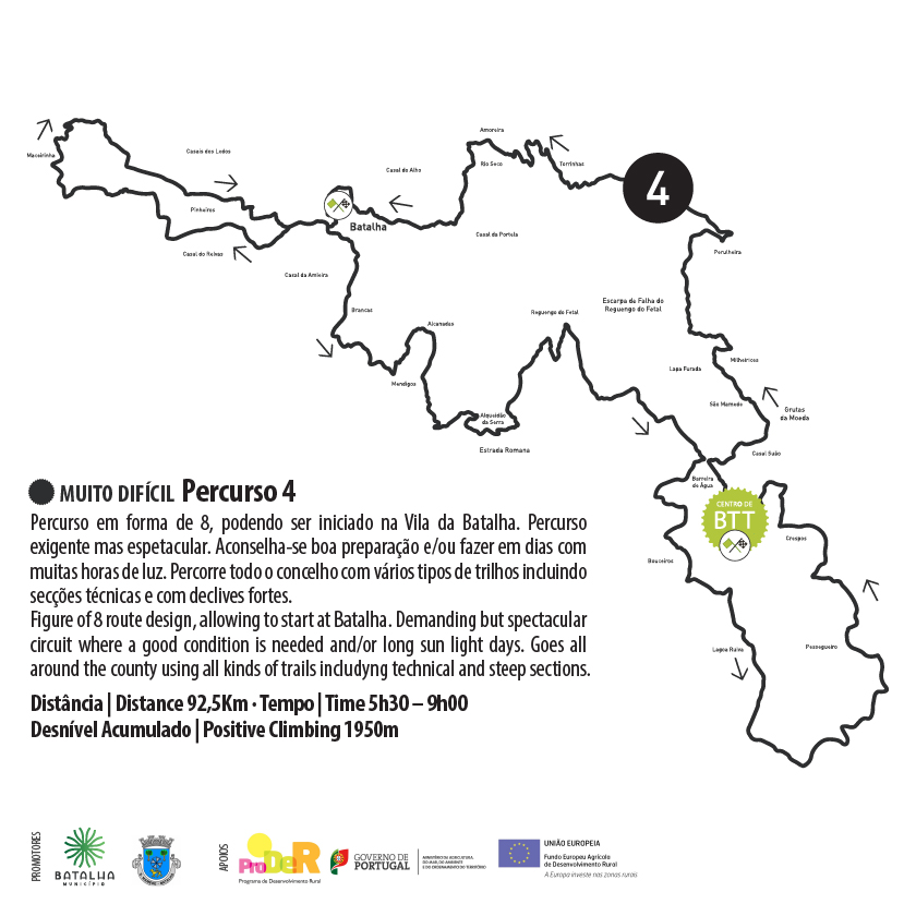
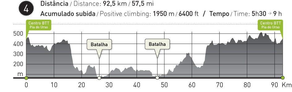
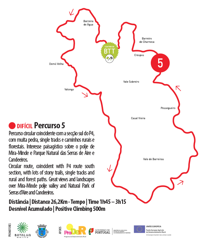
Considered to be one of Turismo de Portugal’s 100 best ideas by EVASÕES Magazine, the Batalha – Pia do Urso Mountain Biking Centre is made up of a building equipped with changing rooms, sanitary facilities, an information area and space for washing bicycles, as well as carrying out small repairs. From here, visitors can benefit from a free network of bike trails, which are all properly signposted and cover a distance of over 300 Km, which are divided into four levels of difficulty, taking keen cyclists through the Municipalities of Batalha, Porto de Mós and Leiria.


The Batalha Centre is proud to have been the first Mountain Biking Centre in the country to be approved by the UVP / Portuguese Cycling Federation.


This centre benefitted from financial support from PRODER – A Rural Development Program


Trail 1

This trail is shaped like a racket, where the start and finish are in the same location, and the central section is circular, taking you through São Mamede, where you can also start. Trail 1 is mainly made up of country tracks that will take you through farmland, olive groves, and eucalyptus and pine forests.


GPS Tracking
PDF of the Route
Google Earth

Trail 2

Trail 2 is a circular trail that will take you down country lanes and forest tracks where there’s some limestone in the ground. This is the route for you if you’re interested in the views and cultural traditions of the villages and natural areas of the São Mamede plateau.


GPS Tracking

Trail 3

Trail 3 is a circular trail through country paths, trails and single forest tracks, where you’ll find a lot of limestone in the ground. This is the route for you if you’re interested in the views and cultural traditions of the villages and natural areas of the São Mamede plateau, upper Maúnça and Reguengo do Fetal.


GPS Tracking
PDF of the Route

Trail 4

Trail 4 will take you in an 8-shape, and begin in the village of Batalha – a demanding route, which will reward you with magnificent views. We advise that you prepare
yourself well for this route, and / or do it on long summer days when you’ll have long hours of daylight. This route will take you across the whole municipality via different types of trails, including sections that will be very technically demanding, as well as some steep slopes.


GPS Tracking
PDF of the Route
Google Earth

Trail 5

Trail 5 is a circular route which coincides with the southern section of T4. The paths are very rocky, taking you through single tracks and country lanes and forest paths. This is the route for you for views over the Mira-Minde polje and the Sierras de Aire e Candeeiros Natural Park.


GPS Tracking
PDF of the Route
Google Earth

Trail 6

Trail 6 is a circular route which has been designed to begin in the town of Batalha but can also have Pia do Urso as its starting point. This route will take you through the centre of our vast network of routes, taking you past emblematic points such as Maúnça and Reguengo do Fetal, via paths that can be rocky, but don’t have a high level of difficulty.


GPS Tracking
PDF of the Route

Trail 7

Short circular route with start/end in Batalha, easy going through pine and eucalyptus forest almost all the way, only raises one difficulty level due to a short sector, know as «Amazonia» of technical single track, but not for long.


GPS Tracking
PDF of the Route
Google Earth