Walking is an excellent, healthy way of getting to know a region. In the municipality of Batalha, you can enjoy four walking trails that will allow you to discover the natural beauty of the landscape, combining it with Heritage, History and Culture. Whether in valleys or up hills, people who love walking can let their feet lead the way on trails that will take them past several species of animals and plants, some of which can’t be found anywhere else in Portugal.
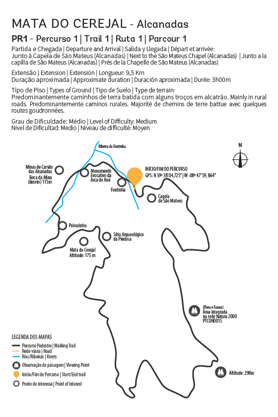
The “ Mata do Cerejal” Walking Trail starts next to the Chapels of São Mateus and Nossa Senhora do “Ó”, which are both classified as religious interest buildings, leading you further on to the main places of interest in Alcanadas. The start of the trail will take you straight through the middle of the Cerejal Woods, a very rich natural area (which is in the Natura 2000 Network), both in terms of species of animals and of plants.
Trail characteristics
Departure and Arrival: Capela de São Mateus
Geographical coordinates: 39º 38 ‘04,725’ ‘-08º 47’ 59,864 ”
Distance: 9.5 Km
Approximate duration: 3 hours
Type of ground: Predominantly country lanes and dirt tracks
Level of difficulty: Medium
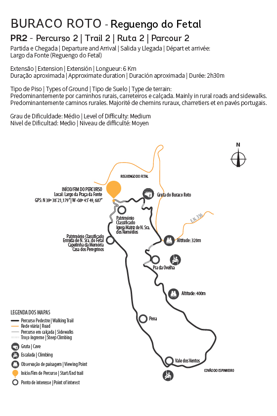
The “Buraco Roto” Walking Trail begins in Largo da Palmeira, right the centre of the Parish of Reguengo do Fetal, continuing towards the “ Buraco Roto” – a necropolis grotto with a beautiful landscape and stunning scenery where, in rainier months, water cascades down the rocks forming a waterfall.
Trail characteristics
Departure and Arrival: Largo da Fonte
Geographical coordinates: 39º 38 ‘21,179 “-08º 45’ 49, 687”
Length: 6 Km
Approximate duration: 2 and a half hours
Type of ground: Predominantly country lanes, dirt tracks and pavements
Degree of difficulty: Medium.
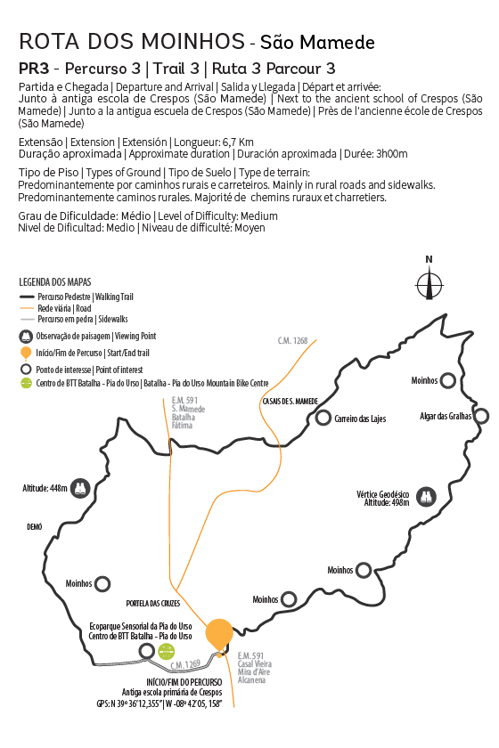
The Windmill Walking Trail begins next to Crespos Primary School, near the Northern entrance of the Pia do Urso Sensory EcoPark. This trail allows visitors to get close to nature, and see numerous species of both flora and fauna. Along with animals and plants, and as the name of this trail suggests, this trail also winds past several windmills, some of which are still in use today.
Trail characteristics
Departure and Arrival: Crespos Primary School
Geographical coordinates: 39º 36 ‘12,355’ ‘-08º 42’ 05,158 ”
Distance: 6.7 Km
Approximate duration: 3 hours
Type of ground: Predominantly country lanes and dirt tracks
Level of difficulty: Medium
Built in the 1920s to transport coal from the small coal basin of Batalha (Mata and Barrojeiras), the Lena branch provided a connection between the Western railway line at Martingança and the historic town, ending at Pinhal Manso, which became known as Estação Velha (Old Station), and is between Vila Facaia and Jardoeira. Charcoal was transported from the mines to Batalha station in wagons and trucks, that were a huge breakthrough for the time, but which could not be the definitive solution for the coal to be transported as fast and as far as possible while still turning a profit.
Trail characteristics
Departure and Arrival: Boitaca Bridge or The Barrojeiras Mines
Geographical coordinates: 39º39’26 ”; – 08º49’54 ” or 39º22’14 “‘- 08º48’15”
Distance: 6 Km
Approximate duration: 1hour and 45 minutes
Type of ground: Narrow paths through country lanes and paved roads
Level of difficulty: Low